
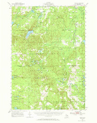
1955 Map of Comins
USGS Topo · Published 1956About this map
Thunder Bay River State Forest dominates this mid-century landscape in the northern Lower Peninsula, where the transition between Montmorency and Oscoda counties is marked by dense clusters of lakes and pockets of early development. The settlement of Comins stands as the primary hub in the south, while the northern sections are largely defined by a network of water bodies such as Avery Lake and Lake Fifteen. Notable for local researchers are the small-scale community markers of the era, including the Loud Sch, the Finnish Cem, and the Loud Cem. The presence of the Sheridan Valley Ski Area and the Atlanta Landing Field reflects a landscape increasingly utilized for recreation and regional transport during the post-war period. Topographic details reveal the complex hydrology of the region, from the Bushman Swamp to the unique Boiling Springs, showing how natural features dictated the placement of early gravel pits and forest boundaries.
Find a feature on this map
65 named features on this map. Tap any name to fly to it.
Don’t see what you’re looking for? This feature index may not catch every label — zoom into the map to look around manually.
Map Details
Editions of this 1955 Comins Map
2 editions found
Other maps of this area

1949 · Lewiston
USGS Topo · 1:62,500

1950 · Lewiston
USGS Topo · 1:24,000

1950 · Comstock Hills
USGS Topo · 1:24,000

1951 · Comstock Hills
USGS Topo · 1:24,000

1951 · Lewiston
USGS Topo · 1:24,000

1954 · Hetherton
USGS Topo · 1:62,500

1954 · Traverse City
USGS Topo · 1:250,000

1954 · Tawas City
USGS Topo · 1:250,000

1954 · Alpena
USGS Topo · 1:250,000

1955 · Atlanta
USGS Topo · 1:62,500