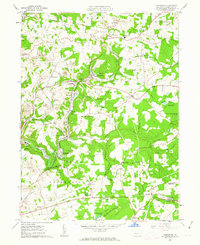
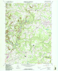
1961 Map of Commodore
USGS Topo · Published 1963About this map
Commodore and the surrounding townships of Grant, Montgomery, and Green reveal an industrial landscape shaped by extraction and rail transport during the early 1960s. Numerous Strip Mine operations and Mine Dump sites are interspersed with small mining settlements like Starford, Heilwood, and Mentcle. The Cherry Tree and Dixonville Branch railroad serves as the primary artery for these operations, winding through the valleys of Two Lick Creek and Yellow Creek.
Find a feature on this map
77 named features on this map. Tap any name to fly to it.
Don’t see what you’re looking for? This feature index may not catch every label — zoom into the map to look around manually.
Map Details
Editions of this 1961 Commodore Map
5 editions found
Other maps of this area

1902 · Indiana
USGS Topo · 1:62,500

1902 · Barnesboro
USGS Topo · 1:62,500

1904 · Barnesboro
USGS Topo · 1:62,500

1906 · Punxsutawney
USGS Topo · 1:62,500

1909 · Smicksburg
USGS Topo · 1:62,500

1938 · Smicksburg
USGS Topo · 1:62,500

1939 · Smicksburg
USGS Topo · 1:62,500

1939 · Punxsutawney
USGS Topo · 1:62,500

1942 · Punxsutawney
USGS Topo · 1:62,500

1943 · Punxsutawney
USGS Topo · 1:125,000
Featured Places
- Rayne Township, PA
- Jewtown, Pine Township
- East Mahoning Township, PA
- Montgomery Township, PA
- Grant Township, PA