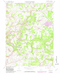
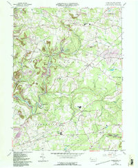
1961 Map of Commodore
USGS Topo · Published 1982About this map
Commodore and the surrounding coal-country townships of Grant, Montgomery, and Green define this portion of Indiana County during the early 1960s. The landscape is heavily marked by the region's industrial heritage, featuring an extensive network of extractive sites like the numerous Strip Mines, a Tipple, and a Conveyor near Wandin Junction. This map captures the intersection of heavy industry and rural community life, where the Conrail lines service the mines while localized hamlets such as Starford, Kenwood, and the Learn Settlement persist in the valleys between the ridges of Turkey Knob and Buck Hill.
Find a feature on this map
77 named features on this map. Tap any name to fly to it.
Don’t see what you’re looking for? This feature index may not catch every label — zoom into the map to look around manually.
Map Details
Editions of this 1961 Commodore Map
5 editions found
Other maps of this area

1902 · Indiana
USGS Topo · 1:62,500

1902 · Barnesboro
USGS Topo · 1:62,500

1904 · Barnesboro
USGS Topo · 1:62,500

1906 · Punxsutawney
USGS Topo · 1:62,500

1909 · Smicksburg
USGS Topo · 1:62,500

1938 · Smicksburg
USGS Topo · 1:62,500

1939 · Smicksburg
USGS Topo · 1:62,500

1939 · Punxsutawney
USGS Topo · 1:62,500

1942 · Punxsutawney
USGS Topo · 1:62,500

1943 · Punxsutawney
USGS Topo · 1:125,000
Featured Places
- Rayne Township, PA
- Jewtown, Pine Township
- East Mahoning Township, PA
- Montgomery Township, PA
- Grant Township, PA