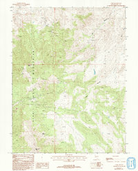
1987 Map of Como
USGS Topo · Published 1993About this map
Mining and high-desert terrain define this area within the Pine Nut Mountains, where the historic district of Como and the Hercules Mine signify the region's silver and gold prospecting legacy. This 1980s-era data highlights a landscape marked by steep relief and remote resource extraction, with high points such as Rawe Peak and Lyon Peak overlooking a network of drainages and springs.
Find a feature on this map
11 named features on this map. Tap any name to fly to it.
Don’t see what you’re looking for? This feature index may not catch every label — zoom into the map to look around manually.
Map Details
Editions of this 1987 Como Map
2 editions found
Other maps of this area

1891 · Carson
USGS Topo · 1:125,000

1891 · Wabuska
USGS Topo · 1:125,000

1893 · Carson
USGS Topo · 1:125,000

1894 · Wabuska
USGS Topo · 1:125,000

1950 · Virginia City
USGS Topo · 1:62,500

1952 · Virginia City
USGS Topo · 1:62,500

1956 · Dayton
USGS Topo · 1:62,500

1957 · Como
USGS Topo · 1:62,500

1957 · Churchill Butte
USGS Topo · 1:62,500

1957 · Reno
USGS Topo · 1:250,000