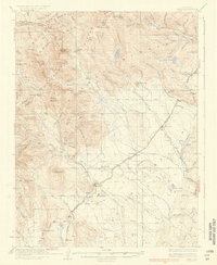
1937 Map of Como
USGS Topo · Published 1937About this map
Como serves as a focal point for the mountain landscape of Park County, where the high-altitude rail lines of the Colorado and Southern dominate the local economy. The network connects several small settlements, including Jefferson, Boreas, and the now-vanished Belmont, as it navigates the demanding grades of the Front Range. The survey highlights the significant industrial presence of the Ute Mine and numerous prospects along French Gulch and American Gulch, reflecting a legacy of mineral extraction that shaped these communities. High mountain crossings such as Boreas Pass and Kenosha Pass define the transport routes between the drainage basins of Tarryall Creek and the North Fork South Platte River. Prominent peaks like Mt Guyot and Boreas Mountain tower over the gulches, illustrating the complex relationship between mining topography and the winding paths of Colorado State Highway No 8.
Find a feature on this map
68 named features on this map. Tap any name to fly to it.
Don’t see what you’re looking for? This feature index may not catch every label — zoom into the map to look around manually.
Map Details
Editions of this 1937 Como Map
3 editions found

Other maps of this area

1889 · Leadville
USGS Topo · 1:125,000

1891 · Leadville
USGS Topo · 1:125,000

1903 · Georgetown
USGS Topo · 1:62,500

1905 · Georgetown
USGS Topo · 1:62,500

1924 · Montezuma
USGS Topo · 1:62,500

1926 · Montezuma
USGS Topo · 1:62,500

1929 · Dillon
USGS Topo · 1:62,500

1933 · Montezuma
USGS Topo · 1:62,500

1934 · Climax
USGS Topo · 1:48,000

1934 · Dillon
USGS Topo · 1:62,500