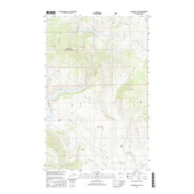
2017 Map of Conconully East
USGS Topo · Published 2017About this map
Ruby Cem stands as a quiet marker of the region’s history just south of Happy Hill, where the land begins its descent toward the Salmon Cr drainage. This portion of the Okanogan National Forest is defined by a high-elevation landscape of peaks and basins, including Schallow Mtn and Funk Mtn. Water is a dominant feature, with the Conconully Reservoir and Conconully Lake anchoring the western edge of the map. These bodies of water, along with smaller alpine features like Sugarloaf Lake and Doheney Lake, illustrate the complex hydrology of the eastern Cascades. To the east, the terrain transitions into the Lime Belt and the Scotch Creek Basin, areas traditionally significant for their geological variety and grazing potential. The map also traces a network of high-country roads such as Sinlahekin Rd and Fish Lake Rd that connect these remote uplands.
Find a feature on this map
54 named features on this map. Tap any name to fly to it.
Don’t see what you’re looking for? This feature index may not catch every label — zoom into the map to look around manually.
Map Details
Editions of this 2017 Conconully East Map
This is the sole edition of this map. No revisions or reprints were ever made.
Other maps of this area

1905 · Okanogan
USGS Topo · 1:125,000

1906 · Chopaka
USGS Topo · 1:125,000

1954 · Okanogan
USGS Topo · 1:250,000

1956 · Loup Loup
USGS Topo · 1:62,500

1956 · Tiffany Mountain
USGS Topo · 1:62,500

1957 · Okanogan
USGS Topo · 1:62,500

1957 · Conconully
USGS Topo · 1:62,500

1958 · Okanogan
USGS Topo · 1:250,000
1980 · Omak
USGS Topo · 1:24,000
1980 · Aeneas Lake
USGS Topo · 1:24,000