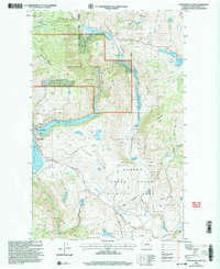
2001 Map of Conconully East
USGS Topo · Published 2004About this map
Conconully lies at the intersection of water and industry at the turn of the 21st century, positioned between the Conconully Reservoir and Conconully Lake. The landscape is defined by the managed resources of the Okanogan National Forest and Loomis State Forest, alongside the conservation lands of the Scotch Creek State Wildlife Area. This area in the Okanogan Highlands reveals a long history of extraction, evidenced by prospect pits and the Peacock Mine near Salmon Creek. Genealogists will find significant value in the documentation of local burial grounds, including the Conconully Cem and the Ruby Cem located south of Graveyard Flat. The terrain rises sharply from the townsite toward landmarks like Funk Mountain and the Lime Belt, showing how early settlement patterns followed the narrow valley floors and water sources.
Find a feature on this map
48 named features on this map. Tap any name to fly to it.
Don’t see what you’re looking for? This feature index may not catch every label — zoom into the map to look around manually.
Map Details
Editions of this 2001 Conconully East Map
This is the sole edition of this map. No revisions or reprints were ever made.
Other maps of this area

1905 · Okanogan
USGS Topo · 1:125,000

1906 · Chopaka
USGS Topo · 1:125,000

1954 · Okanogan
USGS Topo · 1:250,000

1956 · Loup Loup
USGS Topo · 1:62,500

1956 · Tiffany Mountain
USGS Topo · 1:62,500

1957 · Okanogan
USGS Topo · 1:62,500

1957 · Conconully
USGS Topo · 1:62,500

1958 · Okanogan
USGS Topo · 1:250,000
1980 · Omak
USGS Topo · 1:24,000
1980 · Aeneas Lake
USGS Topo · 1:24,000