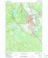
1967 Map of Concord
USGS Topo · Published 1985About this map
The Merrimack River serves as the central artery for this mid-century capital landscape, winding past the urban core of Concord and defining the industrial and agricultural character of the region. This 1967 survey, with revisions from the early 1980s, reveals a city in transition, where established institutions like the State Hospital and St Pauls Sch occupy large tracts of land while the Everett Turnpike and numerous interchanges signal postwar suburban expansion. The terrain is marked by distinctive elevations such as Rattlesnake Hill and Rum Hill, overlooking the dense network of cemeteries including Blossom Hill Cemetery and Old North Cem.
Find a feature on this map
104 named features on this map. Tap any name to fly to it.
Don’t see what you’re looking for? This feature index may not catch every label — zoom into the map to look around manually.
Map Details
Editions of this 1967 Concord Map
3 editions found
Other maps of this area

1919 · Gilmanton
USGS Topo · 1:62,500

1921 · Suncook
USGS Topo · 1:62,500

1927 · Concord
USGS Topo · 1:62,500

1927 · Penacook
USGS Topo · 1:62,500

1927 · Gilmanton
USGS Topo · 1:62,500

1944 · Suncook
USGS Topo · 1:62,500

1949 · Portland
USGS Topo · 1:250,000

1949 · Concord
USGS Topo · 1:62,500

1956 · Penacook
USGS Topo · 1:62,500

1956 · Portland
USGS Topo · 1:250,000