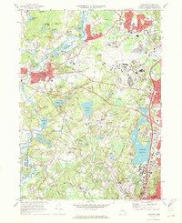
1970 Map of Concord
USGS Topo · Published 1972About this map
Sleepy Hollow Cemetery and the literary landmarks of Authors Ridge anchor this survey of a landscape deeply shaped by American history and literature. The map documents the convergence of the Concord River, Assabet River, and Sudbury River at the Egg Rock junction. At the heart of the region, the Minute Man Mon stands near the historic crossing of the river, while Revolutionary Ridge and Meriam Corner mark the path of colonial conflict. The mid-century expansion of Hanscom Field and the surrounding road network, including the cloverleaf interchanges near Hastings, contrasts with the preserved waters of Walden Pond State Res and the marshlands of the Great Meadows National Wildlife Refuge. Traces of the older agrarian and social fabric remain visible through features like the Old Burying Ground in Lincoln and numerous local schools such as the Emerson Sch and Alcott Sch.
Find a feature on this map
167 named features on this map. Tap any name to fly to it.
Don’t see what you’re looking for? This feature index may not catch every label — zoom into the map to look around manually.
Map Details
Editions of this 1970 Concord Map
3 editions found
Other maps of this area

1886 · Lawrence
USGS Topo · 1:62,500

1886 · Lowell
USGS Topo · 1:62,500

1886 · Framingham
USGS Topo · 1:62,500

1888 · Lawrence
USGS Topo · 1:62,500

1889 · Framingham
USGS Topo · 1:62,500

1893 · Lowell
USGS Topo · 1:62,500

1893 · Boston
USGS Topo · 1:62,500

1893 · Lawrence
USGS Topo · 1:62,500

1894 · Framingham
USGS Topo · 1:62,500

1903 · Boston
USGS Topo · 1:62,500