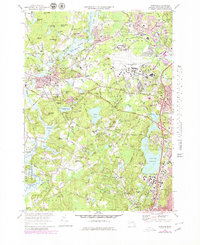
1970 Map of Concord
USGS Topo · Published 1979About this map
Concord and its literary and revolutionary heritage are central to this landscape, where landmarks like the Old North Bridge and the Minute Man Mon reflect the town's historical prominence. The map shows the dense network of local roads such as the Cambridge Turnpike and Lexington Road meeting at the town center, while Authors Ridge and the Old Burying Ground highlight the area's deep genealogical roots. To the south, the preservation of natural spaces is evident in the Walden Pond State Res, famously associated with Henry David Thoreau, and the extensive Great Meadows National Wildlife Refuge bordering the Sudbury River.
Find a feature on this map
107 named features on this map. Tap any name to fly to it.
Don’t see what you’re looking for? This feature index may not catch every label — zoom into the map to look around manually.
Map Details
Editions of this 1970 Concord Map
3 editions found
Other maps of this area

1886 · Lawrence
USGS Topo · 1:62,500

1886 · Lowell
USGS Topo · 1:62,500

1886 · Framingham
USGS Topo · 1:62,500

1888 · Lawrence
USGS Topo · 1:62,500

1889 · Framingham
USGS Topo · 1:62,500

1893 · Lowell
USGS Topo · 1:62,500

1893 · Boston
USGS Topo · 1:62,500

1893 · Lawrence
USGS Topo · 1:62,500

1894 · Framingham
USGS Topo · 1:62,500

1903 · Boston
USGS Topo · 1:62,500