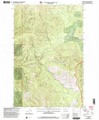
1999 Map of Coney Peak
USGS Topo · Published 2003About this map
The Cabinet Mountains define the high country of Sanders County in the late 1990s, where the western boundary of the Flathead Indian Reservation meets the protected lands of the Lolo National Forest. This montane landscape is shaped by the headwaters of the Little Thompson River and its various tributaries, including Nancy Creek and Alder Creek. A high-altitude drainage pattern is evident at Corona Lake, situated near the Corona Divide. Human infrastructure in this wilderness is limited to specialized water management and recreation, notably the McGinnis Ditch and the Baldy Lake Nat Rec Trail. The map provides a detailed view of the terrain around Coney Peak, capturing the complex network of gulches and creeks such as Noble Gulch and Foothen Creek that drain the high ridges.
Find a feature on this map
19 named features on this map. Tap any name to fly to it.
Don’t see what you’re looking for? This feature index may not catch every label — zoom into the map to look around manually.
Map Details
Editions of this 1999 Coney Peak Map
This is the sole edition of this map. No revisions or reprints were ever made.
Other maps of this area

1956 · Wallace
USGS Topo · 1:250,000

1960 · Wallace
USGS Topo · 1:250,000

1964 · Mill Pocket Creek
USGS Topo · 1:24,000

1964 · Coney Peak
USGS Topo · 1:24,000

1964 · Baldy Lake
USGS Topo · 1:24,000
1964 · Cook Mountain
USGS Topo · 1:24,000

1964 · Weeksville
USGS Topo · 1:24,000

1964 · Lonepine
USGS Topo · 1:24,000

1964 · Hot Springs
USGS Topo · 1:24,000
1964 · Bassoo Peak
USGS Topo · 1:24,000