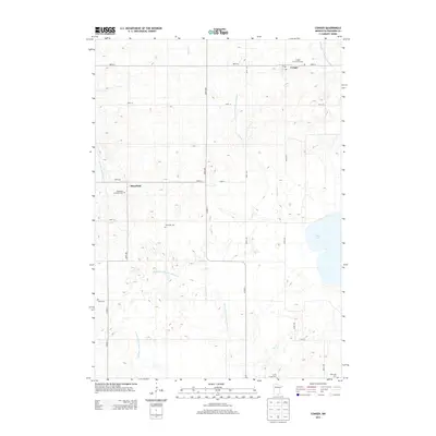
2013 Map of Conger
USGS Topo · Published 2013About this map
Conger and Mansfield anchor this rural landscape in Freeborn County, reflecting a settlement pattern deeply tied to agricultural drainage and local waterways. The terrain is defined by an extensive network of managed water systems, including Judicial Ditch Number Twentyfive, Judicial Ditch Number Twentysix, and County Ditch Number Fortyeight, which facilitate farming across the low-lying prairie. For those tracing local heritage, the map identifies several small burial sites that mark early community nodes, such as Conger Community Cem, Mansfield Lutheran Cem, and the Schnieder Cem. Natural water bodies like Bear Lake and the E Br Blue Earth River persist alongside the engineered ditches. This 2013 survey provides a clear view of the intersection between traditional township life and the modernization of the Minnesota countryside.
Find a feature on this map
30 named features on this map. Tap any name to fly to it.
Don’t see what you’re looking for? This feature index may not catch every label — zoom into the map to look around manually.
Map Details
Editions of this 2013 Conger Map
This is the sole edition of this map. No revisions or reprints were ever made.
Other maps of this area

1954 · Albert Lea
USGS Topo · 1:62,500

1954 · Mason City
USGS Topo · 1:250,000

1955 · Wells
USGS Topo · 1:62,500

1957 · Mason City
USGS Topo · 1:250,000

1958 · Mason City
USGS Topo · 1:250,000

1972 · Bristol
USGS Topo · 1:24,000

1972 · Vinje
USGS Topo · 1:24,000
1972 · Lake Mills
USGS Topo · 1:24,000

1982 · Albert Lea West
USGS Topo · 1:24,000
1982 · Emmons
USGS Topo · 1:24,000