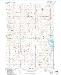
1982 Map of Conger
USGS Topo · Published 1983About this map
Conger and the surrounding townships of Alden and Mansfield define this agricultural landscape in Freeborn County during the early 1980s. The region is heavily marked by a complex system of drainage infrastructure, including County Ditch No 48 and Judicial Ditch No 26, which illustrates the extensive modification of the wet prairie to support cultivation. In the southwest, the small settlement of Sletten sits near the Freeborn and Winnebago county line, while the eastern portion of the map is dominated by the waters of Pickerel Lake and Bear Lake. Cultural and genealogical history is preserved in several rural landmarks, such as Lime Creek Church and its associated Lime Creek Cemetery, along with smaller family burial sites like Schnieder Cemetery. Conservation efforts are represented by the Bear Lake State Wildlife Management Area, which protects the shoreline and marshy periphery of the lake.
Find a feature on this map
30 named features on this map. Tap any name to fly to it.
Don’t see what you’re looking for? This feature index may not catch every label — zoom into the map to look around manually.
Map Details
Editions of this 1982 Conger Map
This is the sole edition of this map. No revisions or reprints were ever made.
Other maps of this area

1954 · Albert Lea
USGS Topo · 1:62,500

1954 · Mason City
USGS Topo · 1:250,000

1955 · Wells
USGS Topo · 1:62,500

1957 · Mason City
USGS Topo · 1:250,000

1958 · Mason City
USGS Topo · 1:250,000

1972 · Bristol
USGS Topo · 1:24,000

1972 · Vinje
USGS Topo · 1:24,000
1972 · Lake Mills
USGS Topo · 1:24,000

1982 · Albert Lea West
USGS Topo · 1:24,000
1982 · Emmons
USGS Topo · 1:24,000