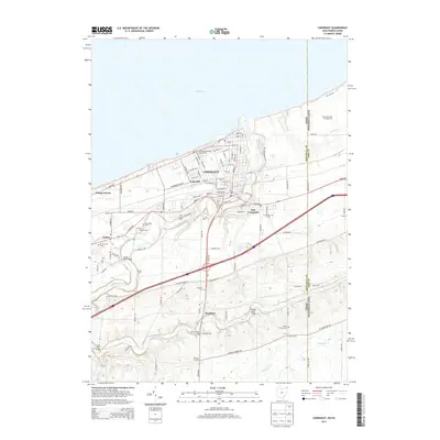
2013 Map of Conneaut
USGS Topo · Published 2013About this map
The waters of Lake Erie define the northern boundary of this lakefront community, where the industrial legacy of the Great Lakes is visible at the Perry Bluff Ore Storage Area. The landscape is dominated by the winding course of Conneaut Creek, which cuts a deep valley through the terrain, spanned by several significant crossings including the Creek Road Bridge and the State Road Bridge. Smaller settlements like Lakeville, Amboy, and East Conneaut form a cluster of residential and commercial activity near the shore, while the southern reaches of the map transition into a more dispersed pattern of rural outposts such as Farnham and Clarks Corner. Genealogists will find a wealth of local history preserved in numerous burial grounds, from the centrally located City Cem to the outlying Durkee Cem and Saint Josephs Cem. This 2013 survey also highlights the interstate border between Ohio and Pennsylvania, marked by State Line Rd.
Find a feature on this map
110 named features on this map. Tap any name to fly to it.
Don’t see what you’re looking for? This feature index may not catch every label — zoom into the map to look around manually.
Map Details
Editions of this 2013 Conneaut Map
This is the sole edition of this map. No revisions or reprints were ever made.
Other maps of this area

1900 · Girard
USGS Topo · 1:62,500

1900 · Fairview
USGS Topo · 1:62,500

1906 · Conneaut
USGS Topo · 1:62,500

1950 · Cleveland
USGS Topo · 1:250,000

1950 · Erie
USGS Topo · 1:250,000

1956 · Cleveland
USGS Topo · 1:250,000

1957 · Fairview SW
USGS Topo · 1:24,000

1959 · East Springfield
USGS Topo · 1:24,000

1959 · Beaver Center
USGS Topo · 1:24,000

1959 · Erie
USGS Topo · 1:250,000