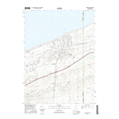
2016 Map of Conneaut
USGS Topo · Published 2016About this map
Lake Erie defines the northern edge of this Lake County landscape, where the waters of Conneaut Creek wind through the terrain before reaching Conneaut Harbor. The city of Conneaut serves as a central hub, with established neighborhoods like East Conneaut and Amboy radiating from the core grid. This modern survey illustrates the dense network of local roads including W Main St and S Ridge Rd E, which connect numerous historic family and community burial grounds. Genealogists will find a concentration of sites such as City Cem, Glenwood Cem, and Saint Josephs Cem within the city limits, while more rural locations like Durkee Cem and Clarks Corner Cem dot the outlying areas. Distinctive engineering features are noted along the waterways, including the Creek Road Bridge, Middle Road Bridge, and State Road Bridge, marking the critical crossing points that have supported the region's transport and growth.
Find a feature on this map
92 named features on this map. Tap any name to fly to it.
Don’t see what you’re looking for? This feature index may not catch every label — zoom into the map to look around manually.
Map Details
Editions of this 2016 Conneaut Map
This is the sole edition of this map. No revisions or reprints were ever made.
Other maps of this area

1900 · Girard
USGS Topo · 1:62,500

1900 · Fairview
USGS Topo · 1:62,500

1906 · Conneaut
USGS Topo · 1:62,500

1950 · Cleveland
USGS Topo · 1:250,000

1950 · Erie
USGS Topo · 1:250,000

1956 · Cleveland
USGS Topo · 1:250,000

1957 · Fairview SW
USGS Topo · 1:24,000

1959 · East Springfield
USGS Topo · 1:24,000

1959 · Beaver Center
USGS Topo · 1:24,000

1959 · Erie
USGS Topo · 1:250,000