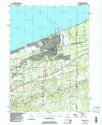
1996 Map of Conneaut
USGS Topo · Published 1996About this map
Conneaut stands as a pivotal lakefront terminal where the meandering path of Conneaut Creek meets Lake Erie. This mid-1990s landscape is defined by its strategic position at the Ohio-Pennsylvania border, serving as a heavy industrial and transportation node. The map details an intricate web of logistics, from the maritime operations at the Conneaut Harbor and its iconic Lighthouse to the heavy rail corridors of Conrail and the Norfolk and Western.
Find a feature on this map
43 named features on this map. Tap any name to fly to it.
Don’t see what you’re looking for? This feature index may not catch every label — zoom into the map to look around manually.
Map Details
Editions of this 1996 Conneaut Map
This is the sole edition of this map. No revisions or reprints were ever made.
Other maps of this area

1900 · Girard
USGS Topo · 1:62,500

1900 · Fairview
USGS Topo · 1:62,500

1906 · Conneaut
USGS Topo · 1:62,500

1950 · Cleveland
USGS Topo · 1:250,000

1950 · Erie
USGS Topo · 1:250,000

1956 · Cleveland
USGS Topo · 1:250,000

1957 · Fairview SW
USGS Topo · 1:24,000

1959 · East Springfield
USGS Topo · 1:24,000

1959 · Beaver Center
USGS Topo · 1:24,000

1959 · Erie
USGS Topo · 1:250,000