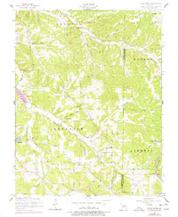
1954 Map of Conns Creek
USGS Topo · Published 1977About this map
Conns Creek and its many tributaries, including Wet Glaize Creek and Deberry Creek, carve a complex drainage pattern through this section of the Ozark Plateau. The landscape in the mid-1950s was defined by small rural hubs and family-named landmarks, such as Hawkeye School in the northeast and Oak Grove School to the west. Evidence of older transport networks is visible along the eastern edge, where the Old Railroad Grade (St Louis-San Francisco) marks a former corridor of the Frisco Line. The area is dotted with local houses of worship like Elm Grove Church and Beulah Church, alongside several family burying grounds including Thornsberry Cemetery and Chalfant Cemetery. Revisions from the 1970s introduce modern infrastructure like the Richland Municipal Airport and a large Pipeline cutting across the southern township of Auglaize.
Find a feature on this map
34 named features on this map. Tap any name to fly to it.
Don’t see what you’re looking for? This feature index may not catch every label — zoom into the map to look around manually.
Map Details
Editions of this 1954 Conns Creek Map
2 editions found
Other maps of this area

1888 · Versailles
USGS Topo · 1:125,000

1888 · Tuscumbia
USGS Topo · 1:125,000

1893 · Versailles
USGS Topo · 1:125,000

1894 · Tuscumbia
USGS Topo · 1:125,000

1932 · Versailles No 4
USGS Topo · 1:48,000

1933 · Stoutland
USGS Topo · 1:62,500

1933 · Iberia
USGS Topo · 1:62,500

1934 · Toronto
USGS Topo · 1:24,000

1937 · Iberia
USGS Topo · 1:62,500

1938 · Stoutland
USGS Topo · 1:62,500