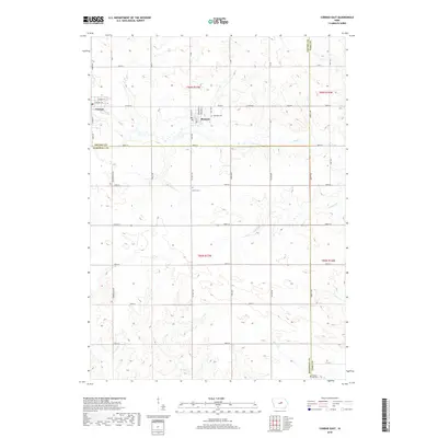
2018 Map of Conrad East
USGS Topo · Published 2018About this map
Wolf Cr and its many tributaries, including Devils Run and Burnett Cr, define the drainage patterns of this central Iowa agricultural landscape. The town of Beaman sits near the center of the survey, where streets like McMartin St and Beckman St form a compact grid just south of Oakland Cem. To the northwest, the edge of Conrad appears along S Main St, marking a point of transition between Grundy and Marshall Counties. The map reveal a rural landscape punctuated by generational landmarks, such as the Vienna Cem and Chapel Hill Cem, which serve as anchors for local family histories. A dense network of county roads, including Co Hwy T29 and Co Rd D67, connects the disparate farmsteads and township sections, reflecting the enduring 19th-century section line grid system that still governs Iowa's prairie geography.
Find a feature on this map
53 named features on this map. Tap any name to fly to it.
Don’t see what you’re looking for? This feature index may not catch every label — zoom into the map to look around manually.
Map Details
Editions of this 2018 Conrad East Map
This is the sole edition of this map. No revisions or reprints were ever made.
Other maps of this area

1954 · Waterloo
USGS Topo · 1:250,000

1955 · Waterloo
USGS Topo · 1:250,000

1960 · Marshalltown
USGS Topo · 1:24,000

1960 · Marshalltown
USGS Topo · 1:62,500

1960 · Le Grand
USGS Topo · 1:24,000

1960 · Conrad West
USGS Topo · 1:24,000

1960 · Conrad East
USGS Topo · 1:24,000

1971 · Lincoln
USGS Topo · 1:24,000

1971 · Garwin
USGS Topo · 1:24,000
1971 · Gladbrook
USGS Topo · 1:24,000