
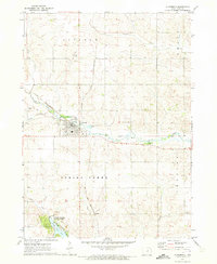
1960 Map of Conrad East
USGS Topo · Published 1966About this map
The town of Conrad stands near the northwest corner of this 1960s Iowa landscape, characterized by the agricultural patterns of Marshall and Grundy counties. The rail infrastructure of the era is prominently displayed, with the Chicago and North Western corridor running through the heart of Beaman and across the drainage of Wolf Creek. Further south, the Chicago Great Western line cuts through the countryside, crossing Spring Creek and tracing the boundary between Marshall and Tama counties.
Find a feature on this map
19 named features on this map. Tap any name to fly to it.
Don’t see what you’re looking for? This feature index may not catch every label — zoom into the map to look around manually.
Map Details
Editions of this 1960 Conrad East Map
This is the sole edition of this map. No revisions or reprints were ever made.
Other maps of this area

1954 · Waterloo
USGS Topo · 1:250,000

1955 · Waterloo
USGS Topo · 1:250,000

1960 · Marshalltown
USGS Topo · 1:24,000

1960 · Marshalltown
USGS Topo · 1:62,500

1960 · Le Grand
USGS Topo · 1:24,000

1960 · Conrad West
USGS Topo · 1:24,000

1971 · Lincoln
USGS Topo · 1:24,000

1971 · Garwin
USGS Topo · 1:24,000
1971 · Gladbrook
USGS Topo · 1:24,000

1979 · Grundy Center
USGS Topo · 1:24,000