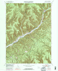
1947 Map of Conrad
USGS Topo · Published 1991About this map
Sinnemahoning Creek East Fork carves a deep path through this corner of Potter County, serving as the primary corridor for movement and early settlement. Along its banks, the small hamlets of Conrad and Logue stand as quiet nodes of activity in a landscape dominated by timber-covered ridges and narrow hollows. The presence of several Gas Wells and a network of pipelines suggests an economy shifting toward resource extraction, while older family-named sites like McFall Cem and Brooks Cem anchor the region's genealogical history.
Find a feature on this map
45 named features on this map. Tap any name to fly to it.
Don’t see what you’re looking for? This feature index may not catch every label — zoom into the map to look around manually.
Map Details
Editions of this 1947 Conrad Map
5 editions found
Other maps of this area

1945 · Driftwood
USGS Topo · 1:48,000

1945 · First Fork
USGS Topo · 1:24,000

1946 · Renovo West
USGS Topo · 1:62,500

1946 · Hammersley Fork
USGS Topo · 1:24,000

1946 · Tamarack
USGS Topo · 1:24,000

1947 · First Fork
USGS Topo · 1:24,000

1947 · Conrad
USGS Topo · 1:62,500

1947 · Conrad
USGS Topo · 1:24,000

1947 · Short Run
USGS Topo · 1:24,000

1947 · Ayers Hill
USGS Topo · 1:24,000
Featured Places
- Wharton Township, PA
- Summit Township, PA
- Sylvania Township, PA
- Hammersley, Wharton Township
- Logue, Wharton Township