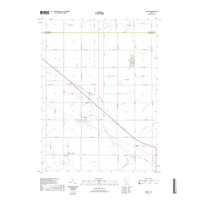
2019 Map of Convoy
USGS Topo · Published 2019About this map
The village of Convoy anchors this section of Van Wert County, where the landscape is defined by the headwaters of numerous creeks and a dense network of township roads. The local drainage pattern is visible through the courses of Monkey Run, Pottawatomie Cr, and Upper Prairie Cr, which carve subtle paths through the agricultural fields. For genealogists and local historians, the map is a detailed record of rural landmarks, including the Sugar Ridge Cem and Township Cem located just outside the village center. Further south, the map identifies the Redeemer Lutheran Cem and Saint Johns Cem near the junction of several county roads, while the small settlement of Richey sits along the eastern edge. This survey documents the persistent rural character of western Ohio, where legacy cemeteries and small stream crossings like Blue Cr remain primary geographic markers.
Find a feature on this map
73 named features on this map. Tap any name to fly to it.
Don’t see what you’re looking for? This feature index may not catch every label — zoom into the map to look around manually.
Map Details
Editions of this 2019 Convoy Map
This is the sole edition of this map. No revisions or reprints were ever made.
Other maps of this area

1914 · Van Wert
USGS Topo · 1:62,500

1914 · Paulding
USGS Topo · 1:62,500

1944 · Van Wert
USGS Topo · 1:62,500

1944 · Paulding
USGS Topo · 1:62,500

1953 · Fort Wayne
USGS Topo · 1:250,000

1953 · Muncie
USGS Topo · 1:250,000

1956 · Muncie
USGS Topo · 1:250,000

1956 · Fort Wayne
USGS Topo · 1:250,000

1958 · Woodburn South
USGS Topo · 1:24,000
1960 · Convoy
USGS Topo · 1:24,000