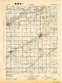
1944 Map of Paulding
USGS Topo · Published 1944About this map
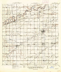
The Maumee River winds through the northern portion of this Paulding County landscape, reflecting the rural settlement patterns of northwest Ohio during the early 1940s. A dense grid of country schools, such as Swamp College and Happy Corner Sch, highlights the importance of local education in a region defined by agricultural townships like Carryall and Benton. The rail network of the Wabash RR and the New York Chicago and St Louis RR serves as the industrial backbone, connecting established towns like Antwerp and Payne to the wider Midwest. Notable landmarks such as the Infirmary near Paulding and the distinctive double-labeling of Charloe provide specific points of interest for local historians. The map also reveals the extensive drainage system of the era, with numerous named waterways like Flatrock Creek and Webster Ditch essential for maintaining the tillable land of this glaciated plain.
Find a feature on this map
84 named features on this map. Tap any name to fly to it.
Don’t see what you’re looking for? This feature index may not catch every label — zoom into the map to look around manually.
Map Details
Editions of this 1944 Paulding Map
This is the sole edition of this map. No revisions or reprints were ever made.
Historical Maps of Paulding Through Time
8 maps found