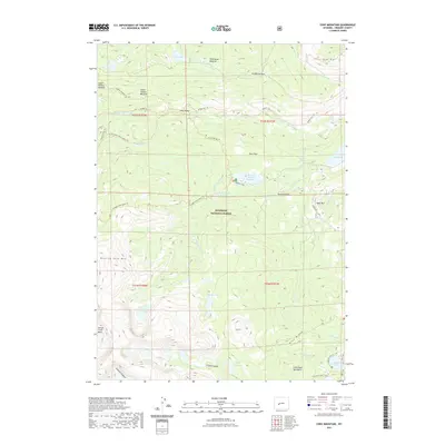
2021 Map of Cony Mountain
USGS Topo · Published 2021About this map
Shoshone National Forest defines this high-elevation landscape in Fremont County, where the hydrological divide of the Blue Ridge and Roaring Fork Mtn shapes the flow of numerous alpine water systems. The map detail highlights a complex network of glacial features, from the Stough Creek Basin to the deep incisions of Silas Canyon and Atlantic Canyon. Human access is primarily represented by a dedicated system of pack trails, including the Hudson Meadow Trl and Christina Lake Trl, which connect remote meadows like Wild Horse Meadow and Lower Hudson Meadow. Significant water management and recreation sites are concentrated at the Worthen Meadow Reservoir and the Fiddlers Lake CG. This terrain, dominated by Cony Mtn, illustrates the protected wilderness character of the Wind River Range, where the Middle Popo Agie River and its tributaries such as Roaring Fork Cr descend toward the basin.
Find a feature on this map
51 named features on this map. Tap any name to fly to it.
Don’t see what you’re looking for? This feature index may not catch every label — zoom into the map to look around manually.
Map Details
Editions of this 2021 Cony Mountain Map
This is the sole edition of this map. No revisions or reprints were ever made.
Other maps of this area

1937 · Moccasin Lake
USGS Topo · 1:48,000

1943 · Moccasin Lake
USGS Topo · 1:62,500

1953 · Sweetwater Gap
USGS Topo · 1:24,000

1953 · Cony Mountain
USGS Topo · 1:24,000

1953 · Mount Arter
USGS Topo · 1:24,000

1953 · Fossil Hill
USGS Topo · 1:24,000

1953 · Louis Lake
USGS Topo · 1:24,000

1953 · Christina Lake
USGS Topo · 1:24,000

1953 · Mount Arter SE
USGS Topo · 1:24,000

1955 · Lander
USGS Topo · 1:250,000