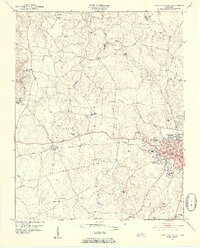
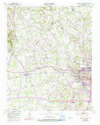
1953 Map of Cookeville West
USGS Topo · Published 1955About this map
Cookeville serves as the focal point of this mid-century survey, revealing the early layout of the Tennessee Polytechnic Institute campus and the essential path of the Tennessee Central railroad cutting through the heart of town. The landscape transitions from the urbanized center of Cookeville, with its General Hospital and City Hall Post Office, into a rural network of small communities defined by family names and local institutions. To the northwest, the Junior Military Academy stands near Bloomington Springs, while the surrounding hills are dotted with landmarks like Lee Seminary and Pilot Knob. The mapping captures a high density of rural infrastructure, including numerous cemeteries such as Mc Broom Cem and Whitson Cem, alongside country schools like Sycamore Sch and Pippin Sch, providing a clear view of the social geography of Putnam County before modern expansion.
Find a feature on this map
67 named features on this map. Tap any name to fly to it.
Don’t see what you’re looking for? This feature index may not catch every label — zoom into the map to look around manually.
Map Details
Editions of this 1953 Cookeville West Map
6 editions found
Other maps of this area

1897 · Standingstone
USGS Topo · 1:125,000

1898 · Standingstone
USGS Topo · 1:125,000

1925 · Gainesboro
USGS Topo · 1:62,500

1929 · Gainesboro
USGS Topo · 1:62,500

1943 · Cookeville
USGS Topo · 1:100,000

1944 · Cookeville
USGS Topo · 1:100,000

1951 · Windle
USGS Topo · 1:24,000

1953 · Cookeville East
USGS Topo · 1:24,000

1953 · Cookeville West
USGS Topo · 1:24,000
1955 · Windle
USGS Topo · 1:24,000