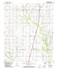
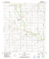
1987 Map of Cookietown
USGS Topo · Published 1988About this map
Cookietown and the surrounding plains of Cotton County are defined by a mix of spiritual landmarks and petroleum extraction in this late-twentieth-century landscape. The small community of Cookietown serves as a local hub near Union Valley Ch, while further north, the presence of Emerson Ch and Emerson Indian Ch reflects the area's social and cultural history. The terrain is bifurcated by the modern H. E. Bailey Turnpike, which cuts a straight path through the eastern half of the map, contrasting with the meandering routes of West Cache Creek and Soldier Creek.
Find a feature on this map
21 named features on this map. Tap any name to fly to it.
Don’t see what you’re looking for? This feature index may not catch every label — zoom into the map to look around manually.
Map Details
Editions of this 1987 Cookietown Map
This is the sole edition of this map. No revisions or reprints were ever made.
Other maps of this area

1955 · Lawton
USGS Topo · 1:250,000

1957 · Burkburnett
USGS Topo · 1:62,500

1957 · Randlett
USGS Topo · 1:62,500

1962 · Chattanooga
USGS Topo · 1:62,500

1962 · Walters
USGS Topo · 1:62,500
1985 · Randlett
USGS Topo · 1:24,000
1985 · Taylor
USGS Topo · 1:24,000
1985 · Devol
USGS Topo · 1:24,000

1985 · Burkburnett
USGS Topo · 1:100,000
1987 · Faxon
USGS Topo · 1:24,000