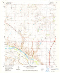
1985 Map of Devol
USGS Topo · Published 1985About this map
The town of Devol serves as the central hub of this mid-1980s survey, positioned along the diagonal route of the Missouri Kansas Texas railroad. The landscape is defined by the sweeping southern boundary of the Red River, where the state line meets the meandering waterway near Goat Island. North of the river, the terrain is shaped by the drainage of Blue Creek and Wildhorse Creek, reflecting a rural economy built on ranching and resource extraction.
Find a feature on this map
17 named features on this map. Tap any name to fly to it.
Don’t see what you’re looking for? This feature index may not catch every label — zoom into the map to look around manually.
Map Details
Editions of this 1985 Devol Map
This is the sole edition of this map. No revisions or reprints were ever made.
Other maps of this area

1915 · Clara
USGS Topo · 1:24,000

1915 · Burkburnett
USGS Topo · 1:24,000

1918 · Buckburnett
USGS Topo · 1:31,680

1918 · Clara
USGS Topo · 1:31,680

1955 · Lawton
USGS Topo · 1:250,000

1957 · Burkburnett
USGS Topo · 1:62,500

1957 · Randlett
USGS Topo · 1:62,500

1962 · Chattanooga
USGS Topo · 1:62,500

1962 · Walters
USGS Topo · 1:62,500
1972 · Clara
USGS Topo · 1:24,000