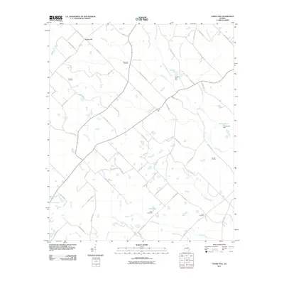
2011 Map of Cooks Still
USGS Topo · Published 2011About this map
Poplar Hill and Cooks Still anchor this rural landscape in central Georgia, where a dense network of watercourses defines the terrain. The topography is shaped by the complex drainage systems of Horse Creek, Alligator Creek, and Little Alligator Creek, which are supplemented by several engineered water bodies including Garrison Lake and Mathews Lake. The area's settlement history is reflected in its family-named roads and remote burial grounds. Genealogists will find interest in the scattered rural cemeteries, such as Studstill Cemetery, Mount Zion Cemetery, Rockwell Cemetery, and Hulett Cemetery. This 2011 survey reveals a landscape largely dominated by forestry and agriculture, connected by a intricate web of county highways and local routes like Villula Church Rd and Mount Zion Church Rd.
Find a feature on this map
64 named features on this map. Tap any name to fly to it.
Don’t see what you’re looking for? This feature index may not catch every label — zoom into the map to look around manually.
Map Details
Editions of this 2011 Cooks Still Map
This is the sole edition of this map. No revisions or reprints were ever made.
Other maps of this area

1953 · Waycross
USGS Topo · 1:250,000

1957 · Macon
USGS Topo · 1:250,000

1958 · Macon
USGS Topo · 1:250,000

1958 · Waycross
USGS Topo · 1:250,000

1964 · Macon
USGS Topo · 1:250,000

1972 · Cooks Still
USGS Topo · 1:24,000

1972 · Jacksonville
USGS Topo · 1:24,000
1972 · Milan
USGS Topo · 1:24,000
1972 · Mc Rae
USGS Topo · 1:24,000

1972 · Lake Cypress
USGS Topo · 1:24,000