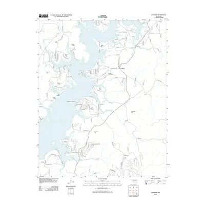
2012 Map of Cookson
USGS Topo · Published 2012About this map
The community of Cookson sits on the eastern shores of Tenkiller Lake in this 2012 topographic record of the Cookson Hills region. This area of eastern Oklahoma is defined by a landscape where the lake's flooded valleys create a jagged shoreline of peninsulas and high vantage points like Cookson Bluff and Turkey Bluff. Transport and recreation are central to the area's layout, highlighted by the presence of the Tenkiller Lake Airpark and the Snake Creek Wilderness Airport further south. The map documents numerous family-named peaks including Griffin Mtn, Canoe Mtn, and Buckhorn Mtn, alongside local burial sites at the Cookson Cem. The road network is dense with small, numbered local routes that serve the various ridges and hollows, such as Ballew Ridge and Pine Hollow, illustrating the modern residential sprawl along the waterfront and surrounding timbered highlands.
Find a feature on this map
139 named features on this map. Tap any name to fly to it.
Don’t see what you’re looking for? This feature index may not catch every label — zoom into the map to look around manually.
Map Details
Editions of this 2012 Cookson Map
This is the sole edition of this map. No revisions or reprints were ever made.
Other maps of this area

1898 · Tahlequah
USGS Topo · 1:125,000

1901 · Muscogee
USGS Topo · 1:125,000

1901 · Tahlequah
USGS Topo · 1:125,000

1905 · Muscogee
USGS Topo · 1:125,000

1905 · Tahlequah
USGS Topo · 1:125,000

1946 · Fort Smith
USGS Topo · 1:250,000

1948 · Hulbert
USGS Topo · 1:62,500

1948 · Webbers Falls
USGS Topo · 1:62,500

1950 · Hulbert
USGS Topo · 1:62,500

1950 · Webbers Falls
USGS Topo · 1:62,500