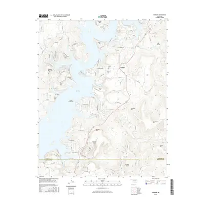
2016 Map of Cookson
USGS Topo · Published 2016About this map
Tenkiller Ferry Lake dominates the western half of this landscape, its sprawling waters and intricate shoreline defining the geography of eastern Oklahoma. Along its eastern banks, the community of Cookson serves as a central hub, accompanied nearby by the Cookson Cem. The terrain is characterized by a series of prominent elevations and ridges, including Buckhorn Mtn, Levi Mtn, and Ballew Ridge, which rise sharply from the lake's edge. Further south, the map captures the border between Cherokee Co and Sequoyah Co, reaching the settlement of Evening Shade. Aviation access is noted at both Tenkiller Lake Airpark and the Snake Creek Wilderness Airport, reflecting the area's development as a recreational and residential destination. The map also highlights several named water features such as Sixshooter Br and Pettit Bay, illustrating the complex drainage patterns feeding the reservoir.
Find a feature on this map
131 named features on this map. Tap any name to fly to it.
Don’t see what you’re looking for? This feature index may not catch every label — zoom into the map to look around manually.
Map Details
Editions of this 2016 Cookson Map
This is the sole edition of this map. No revisions or reprints were ever made.
Other maps of this area

1898 · Tahlequah
USGS Topo · 1:125,000

1901 · Muscogee
USGS Topo · 1:125,000

1901 · Tahlequah
USGS Topo · 1:125,000

1905 · Muscogee
USGS Topo · 1:125,000

1905 · Tahlequah
USGS Topo · 1:125,000

1946 · Fort Smith
USGS Topo · 1:250,000

1948 · Hulbert
USGS Topo · 1:62,500

1948 · Webbers Falls
USGS Topo · 1:62,500

1950 · Hulbert
USGS Topo · 1:62,500

1950 · Webbers Falls
USGS Topo · 1:62,500