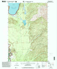
1996 Map of Coolin
USGS Topo · Published 1999About this map
Coolin and the nearby cabins of Sherwood Beach sit along the southeastern shoreline of Priest Lake in this late-twentieth-century revision. The settlement pattern here is dictated by the water, with developments clustered near the Normal Pool Elevation 2438 while the interior remains dominated by the Kaniksu National Forest and Priest Lake State Forest. The geography transitions from the level Jack Pine Flats in the west to the ascending ridges of the Selkirk Mountains in the east, where Sundance Mtn and Whitetail Butte overlook the drainage basins of the Priest River and its various forks. Notable for recreation and resource management, the map identifies the Chase Lake Fishing Access and several Gravel Pit locations, reflecting the local intersection of timber, tourism, and mountain transit.
Find a feature on this map
22 named features on this map. Tap any name to fly to it.
Don’t see what you’re looking for? This feature index may not catch every label — zoom into the map to look around manually.
Map Details
Editions of this 1996 Coolin Map
This is the sole edition of this map. No revisions or reprints were ever made.
Other maps of this area

1901 · Sandpoint
USGS Topo · 1:125,000

1911 · Priest Lake
USGS Topo · 1:250,000

1911 · Sandpoint
USGS Topo · 1:125,000

1913 · Priest Lake
USGS Topo · 1:250,000

1958 · Sandpoint
USGS Topo · 1:250,000

1963 · Sandpoint
USGS Topo · 1:250,000

1967 · Quartz Mtn
USGS Topo · 1:24,000

1967 · Priest Lake SE
USGS Topo · 1:24,000

1967 · Coolin
USGS Topo · 1:24,000
1967 · Outlet Bay
USGS Topo · 1:24,000