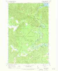
1967 Map of Outlet Bay
USGS Topo · Published 1971About this map
Kaniksu National Forest defines the rugged landscape of this Bonner County quadrangle, where the southern waters of Priest Lake spill into the Priest River. The control point at Outlet Dam and the nearby Gaging Station reflect the managed hydrology of this timber-rich region in the late 1960s. Lowland areas such as Big Meadows and Gleason Meadow break the dense forest cover, while several creek systems, including Upper West Branch Creek and Dubius Creek, drain the high ground. Recreation and forestry infrastructure are evident at Dickensheet Junction and the Outlet Campground. Along the river's winding course, natural features like Mission Falls and Chipmunk Rapids highlight the challenging terrain that shaped early travel and resource extraction in northern Idaho.
Find a feature on this map
34 named features on this map. Tap any name to fly to it.
Don’t see what you’re looking for? This feature index may not catch every label — zoom into the map to look around manually.
Map Details
Editions of this 1967 Outlet Bay Map
3 editions found
Other maps of this area

1901 · Sandpoint
USGS Topo · 1:125,000

1911 · Priest Lake
USGS Topo · 1:250,000

1911 · Sandpoint
USGS Topo · 1:125,000

1913 · Priest Lake
USGS Topo · 1:250,000

1934 · Metaline
USGS Topo · 1:125,000

1936 · Newport
USGS Topo · 1:96,000

1942 · Metaline
USGS Topo · 1:125,000

1942 · Newport
USGS Topo · 1:125,000

1958 · Sandpoint
USGS Topo · 1:250,000

1963 · Sandpoint
USGS Topo · 1:250,000