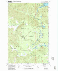
1967 Map of Outlet Bay
USGS Topo · Published 1983About this map
Priest Lake serves as the focal point of this northern Idaho landscape, where the waters flow southward through the Outlet Dam into the winding Priest River. The 1967 field-checked data captures a region defined by its timber and water resources, with the Kaniksu National Forest covering much of the terrain. Small settlements and crossroads like Outlet Bay and Dickensheet Junction provide the primary human footprints in an area dominated by natural features.
Find a feature on this map
29 named features on this map. Tap any name to fly to it.
Don’t see what you’re looking for? This feature index may not catch every label — zoom into the map to look around manually.
Map Details
Editions of this 1967 Outlet Bay Map
3 editions found
Other maps of this area

1901 · Sandpoint
USGS Topo · 1:125,000

1911 · Priest Lake
USGS Topo · 1:250,000

1911 · Sandpoint
USGS Topo · 1:125,000

1913 · Priest Lake
USGS Topo · 1:250,000

1934 · Metaline
USGS Topo · 1:125,000

1936 · Newport
USGS Topo · 1:96,000

1942 · Metaline
USGS Topo · 1:125,000

1942 · Newport
USGS Topo · 1:125,000

1958 · Sandpoint
USGS Topo · 1:250,000

1963 · Sandpoint
USGS Topo · 1:250,000