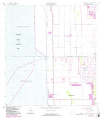
1963 Map of Cooper City SW
USGS Topo · Published 1984About this map
The Everglades Wildlife Management Area dominates the western half of this landscape, where a sophisticated network of water control structures defines the border between the wilderness and emerging suburban development. Extensive levee systems, including Levee No 37, Levee No 39, and Levee No 68A, manage water flow into Conservation Area No 3A, where water is impounded periodically. These engineering works stand in stark contrast to the encroaching residential grids of Pembroke Pines and Rolling Oak Acres to the east.
Find a feature on this map
18 named features on this map. Tap any name to fly to it.
Don’t see what you’re looking for? This feature index may not catch every label — zoom into the map to look around manually.
Map Details
Editions of this 1963 Cooper City SW Map
4 editions found
Other maps of this area

1949 · Opalocka
USGS Topo · 1:24,000

1956 · Miami
USGS Topo · 1:250,000

1956 · West Palm Beach
USGS Topo · 1:250,000

1957 · West Palm Beach
USGS Topo · 1:250,000

1958 · West Palm Beach
USGS Topo · 1:250,000

1958 · Miami
USGS Topo · 1:250,000

1962 · Opa-locka
USGS Topo · 1:24,000

1963 · Andytown
USGS Topo · 1:24,000

1963 · Pennsuco
USGS Topo · 1:24,000

1963 · Cooper City SW
USGS Topo · 1:24,000