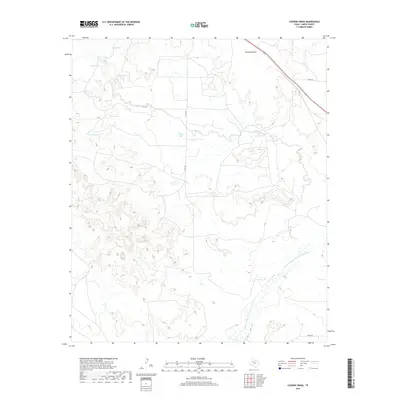
2019 Map of Cooper Creek
USGS Topo · Published 2019About this map
The Double Mountain Fork Brazos River winds through this corner of Garza County, defining the drainage patterns of a landscape marked by intermittent streams and ranching infrastructure. Numerous named water catchments, such as Kelly Tank and Crowley Tank, are distributed across the terrain, reflecting the essential role of water management in this part of West Texas. These features, along with others like Frog Tank and Pipe Tank, often indicate historical property boundaries or family-named landmarks. The topographic relief is highlighted by Two Bush Knob in the northeast, while the drainage of Cooper Creek provides a central corridor for the local watershed. A modest network of county roads, including Co RD 235, connects these disparate points across the prairie.
Find a feature on this map
15 named features on this map. Tap any name to fly to it.
Don’t see what you’re looking for? This feature index may not catch every label — zoom into the map to look around manually.
Map Details
Editions of this 2019 Cooper Creek Map
This is the sole edition of this map. No revisions or reprints were ever made.
Other maps of this area

1954 · Lubbock
USGS Topo · 1:250,000

1954 · Big Spring
USGS Topo · 1:250,000

1958 · Big Spring
USGS Topo · 1:250,000

1969 · Gail NE
USGS Topo · 1:24,000

1969 · Beal Hollow
USGS Topo · 1:24,000

1969 · Fluvanna
USGS Topo · 1:24,000
1969 · Justiceburg NW
USGS Topo · 1:24,000

1969 · Post East
USGS Topo · 1:24,000

1969 · Justiceburg
USGS Topo · 1:24,000

1969 · Post West
USGS Topo · 1:24,000