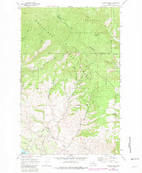
1968 Map of Cooper Ridge
USGS Topo · Published 1981About this map
Mountainous ridges and drainage basins define this 1968 survey of the high country north of Lake Chelan. The landscape is bisected by the boundary between the Wenatchee National Forest and the Okanogan National Forest, with significant terrain markers such as Goff Peak and Washington Butte rising above the watershed. To the south, the terrain transitions into a more developed ranching and agricultural zone, where the network of Boyd Allotment Road and Klaz Allotment Road serves the upland pastures and canyons. The presence of an Aqueduct and multiple reservoirs suggests the critical importance of water management in this high-elevation environment. Detailed trail systems, including various Jeep Trails and Cooper Mtn Road, trace the ridgelines of Cooper Ridge, illustrating how the region was navigated for forestry and land management in the late 1960s.
Find a feature on this map
31 named features on this map. Tap any name to fly to it.
Don’t see what you’re looking for? This feature index may not catch every label — zoom into the map to look around manually.
Map Details
Editions of this 1968 Cooper Ridge Map
4 editions found
Other maps of this area

1899 · Methow
USGS Topo · 1:125,000

1901 · Chelan
USGS Topo · 1:125,000

1901 · Methow
USGS Topo · 1:125,000

1905 · Okanogan
USGS Topo · 1:125,000

1953 · Ritzville
USGS Topo · 1:250,000

1954 · Okanogan
USGS Topo · 1:250,000

1955 · Concrete
USGS Topo · 1:250,000

1957 · Brewster
USGS Topo · 1:62,500

1957 · Wenatchee
USGS Topo · 1:250,000

1958 · Concrete
USGS Topo · 1:250,000