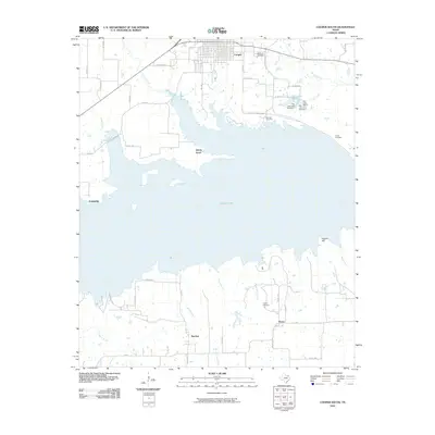
2010 Map of Cooper South
USGS Topo · Published 2010About this map
Cooper Lake dominates the central landscape of this Delta County region, its expansive waters submerging much of the basin once defined by the Doctors Creek and Big Creek floodplains. To the north, the town of Cooper sits at the edge of this transition, marked by established sites such as Oak Lawn Cemetery and the localized City Lakes system. The map documents a rural network of small communities and family-associated landmarks surrounding the water, including Liberty Grove on a southern peninsula and the settlements of Friendship, Peerless, and Posey further inland. Significant local heritage is preserved in the locations of Dawson Cemetery, Tucker Cemetery, and Lindley Cemetery, which remain as fixed points while the surrounding terrain was reshaped by the reservoir. Diverse watercourses like Buggy Whip Creek and Finley Branch continue to drain the south, providing a detailed record of the area's hydrology and land use.
Find a feature on this map
51 named features on this map. Tap any name to fly to it.
Don’t see what you’re looking for? This feature index may not catch every label — zoom into the map to look around manually.
Map Details
Editions of this 2010 Cooper South Map
This is the sole edition of this map. No revisions or reprints were ever made.
Other maps of this area

1953 · Texarkana
USGS Topo · 1:250,000

1956 · Texarkana
USGS Topo · 1:250,000

1964 · Cumby
USGS Topo · 1:24,000

1964 · Sulphur Springs
USGS Topo · 1:24,000

1964 · Gafford Chapel
USGS Topo · 1:24,000

1964 · Klondike
USGS Topo · 1:24,000

1964 · Charleston
USGS Topo · 1:24,000

1964 · Tira
USGS Topo · 1:24,000

1964 · Cooper North
USGS Topo · 1:24,000

1964 · Pecan Gap
USGS Topo · 1:24,000