
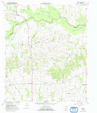
1964 Map of Tira
USGS Topo · Published 1968About this map
The South Sulphur River and its numerous tributaries, including Post Oak Creek, Brushy Creek, and Little Caney Creek, dominate this rural landscape in north Texas during the mid-1960s. The terrain is a network of small upland communities and family landmarks, with Tira and Birthright serving as local hubs. The proximity of New Birthright to the original Birthright settlement reflects shifts in local development and population centers during this era. Educational and spiritual life is anchored by the North Hopkins Sch and several remote burial grounds like the Aiguier Cem and Rushing Cem. The presence of a significant Pipeline cutting through the countryside near Addran indicates the growing infrastructure supporting the region's energy sector. This survey captures the county's agricultural character just before later reservoir projects altered the river's path and the surrounding floodplains.
Find a feature on this map
33 named features on this map. Tap any name to fly to it.
Don’t see what you’re looking for? This feature index may not catch every label — zoom into the map to look around manually.
Map Details
Editions of this 1964 Tira Map
2 editions found
Other maps of this area

1953 · Texarkana
USGS Topo · 1:250,000

1956 · Texarkana
USGS Topo · 1:250,000

1962 · Sulphur Bluff
USGS Topo · 1:24,000

1963 · Minter
USGS Topo · 1:24,000

1964 · Sulphur Springs
USGS Topo · 1:24,000

1964 · Gafford Chapel
USGS Topo · 1:24,000

1964 · Charleston
USGS Topo · 1:24,000

1964 · Cooper North
USGS Topo · 1:24,000
1964 · Cooper South
USGS Topo · 1:24,000
1965 · Dike
USGS Topo · 1:24,000