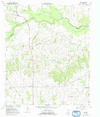
1964 Map of Tira
USGS Topo · Published 1992About this map
The South Sulphur River winds along the northern boundary of this Hopkins County landscape, forming the natural divide between it and Delta County. In the mid-1960s, this rural area was defined by a dense network of small farming settlements and family-named landmarks. The village of Birthright and its neighbor New Birthright anchor the southern portion of the sheet, while Tira and Weir sit further north along the path of Route 154.
Find a feature on this map
39 named features on this map. Tap any name to fly to it.
Don’t see what you’re looking for? This feature index may not catch every label — zoom into the map to look around manually.
Map Details
Editions of this 1964 Tira Map
2 editions found
Other maps of this area

1953 · Texarkana
USGS Topo · 1:250,000

1956 · Texarkana
USGS Topo · 1:250,000

1962 · Sulphur Bluff
USGS Topo · 1:24,000

1963 · Minter
USGS Topo · 1:24,000

1964 · Sulphur Springs
USGS Topo · 1:24,000

1964 · Gafford Chapel
USGS Topo · 1:24,000

1964 · Charleston
USGS Topo · 1:24,000

1964 · Tira
USGS Topo · 1:24,000

1964 · Cooper North
USGS Topo · 1:24,000
1964 · Cooper South
USGS Topo · 1:24,000