1985 Map of Cooperstown
USGS Topo · Published 1985About this map
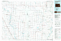
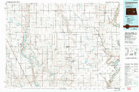
Cooperstown serves as a central hub in this prairie landscape, where the agricultural grid is defined by the Burlington Northern and Soo Line railroads. The map illustrates a region heavily shaped by water management and conservation, anchored by the Arrowwood National Wildlife Refuge and the sprawling Lake Ashtabula created by the Baldhill Dam on the Sheyenne River. Smaller agrarian settlements like Wimbledon, Hannaford, and Courtenay are scattered across the plains, often situated near water bodies such as Spiritwood Lake and Jim Lake. The presence of numerous smaller lakes and sloughs, including Omer Slough and Phelps Lake, reflects the glaciated terrain of the Missouri Coteau. Local industry is represented by features like the Sandpit and a series of municipal improvements such as the Sewage Disposal and Municipal Airport near the larger towns.
Find a feature on this map
78 named features on this map. Tap any name to fly to it.
Don’t see what you’re looking for? This feature index may not catch every label — zoom into the map to look around manually.
Map Details
Editions of this 1985 Cooperstown Map
2 editions found
Historical Maps of Cooperstown Through Time
1 maps found