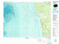
1980 Map of Copalis Beach
USGS Topo · Published 1988About this map
The Quinault Indian Reservation and the rugged coastline of Grays Harbor County dominate this coastal study, illustrating the meeting point of the Olympic Peninsula's river systems and the Pacific shelf. Significant bathymetric detail reveals the underwater contours of the Pacific Ocean, highlighting offshore landmarks like Sea Lion Rock and Sonora Reef. Inland, the map captures the late 20th-century settlement patterns along the coast, where the Burlington Northern line once connected seaside communities such as Moclips and Aloha.
Find a feature on this map
61 named features on this map. Tap any name to fly to it.
Don’t see what you’re looking for? This feature index may not catch every label — zoom into the map to look around manually.
Map Details
Editions of this 1980 Copalis Beach Map
This is the sole edition of this map. No revisions or reprints were ever made.
Other maps of this area

1921 · Quinault Lake
USGS Topo · 1:62,500

1938 · Moclips
USGS Topo · 1:62,500

1941 · Moclips
USGS Topo · 1:62,500

1941 · Grayland
USGS Topo · 1:62,500

1943 · Humptulips
USGS Topo · 1:62,500

1943 · Copalis Beach
USGS Topo · 1:250,000

1951 · Copalis Beach
USGS Topo · 1:250,000

1953 · Hoquiam
USGS Topo · 1:250,000

1955 · Taholah
USGS Topo · 1:62,500

1955 · Macafee Hill
USGS Topo · 1:62,500