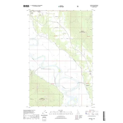
2020 Map of Copeland
USGS Topo · Published 2020About this map
The Kootenai River carves a massive, serpentine path through this international border region, defining the lowlands between the Purcell Mountains and the Kaniksu National Forest. In the northern reach, the settlement of Porthill stands at the edge of the valley floor below Stein Mtn, serving as a historic point of transit. Further south, the community of Copeland is situated near the river's bend, where local history is anchored by the Copeland Cem and the Independent Order of Odd Fellows Cem. The landscape transitions from the agricultural river plains to high peaks such as Eneas Peak and Hall Mtn. Significant backcountry access is highlighted by the Pacific NW National Scenic Trail, which traverses the high ridges, while a network of rural routes like Farm to Market Rd connects the valley's scattered homesteads and water bodies like Kerr Lake and Bass Lake.
Find a feature on this map
49 named features on this map. Tap any name to fly to it.
Don’t see what you’re looking for? This feature index may not catch every label — zoom into the map to look around manually.
Map Details
Editions of this 2020 Copeland Map
This is the sole edition of this map. No revisions or reprints were ever made.
Other maps of this area

1911 · Priest Lake
USGS Topo · 1:250,000

1913 · Priest Lake
USGS Topo · 1:250,000

1958 · Sandpoint
USGS Topo · 1:250,000

1963 · Sandpoint
USGS Topo · 1:250,000

1965 · Farnham Peak
USGS Topo · 1:24,000

1965 · Ritz
USGS Topo · 1:24,000

1965 · Copeland
USGS Topo · 1:24,000

1965 · Hall Mountain
USGS Topo · 1:24,000

1968 · Smith Falls
USGS Topo · 1:24,000

1969 · Pyramid Peak
USGS Topo · 1:24,000