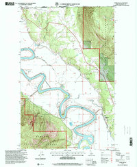
1996 Map of Copeland
USGS Topo · Published 2000About this map
The Canada United States border defines the northern edge of this northern Idaho landscape, where the wide, winding channel of the Kootenai River snakes through a deep valley. The international boundary passes just north of Porthill, a small settlement situated near the foot of Stein Mtn. This area reflects a long history of resource extraction and mountain transit, evidenced by the Golden Scepter Mine in the north and the Montgomery Mine further south near the edge of the Kaniksu National Forest.
Find a feature on this map
27 named features on this map. Tap any name to fly to it.
Don’t see what you’re looking for? This feature index may not catch every label — zoom into the map to look around manually.
Map Details
Editions of this 1996 Copeland Map
This is the sole edition of this map. No revisions or reprints were ever made.
Other maps of this area

1911 · Priest Lake
USGS Topo · 1:250,000

1913 · Priest Lake
USGS Topo · 1:250,000

1958 · Sandpoint
USGS Topo · 1:250,000

1963 · Sandpoint
USGS Topo · 1:250,000

1965 · Farnham Peak
USGS Topo · 1:24,000

1965 · Ritz
USGS Topo · 1:24,000

1965 · Copeland
USGS Topo · 1:24,000

1965 · Hall Mountain
USGS Topo · 1:24,000

1968 · Smith Falls
USGS Topo · 1:24,000

1969 · Pyramid Peak
USGS Topo · 1:24,000