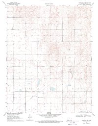
1969 Map of Copeland NE
USGS Topo · Published 1971About this map
Wild Horse Lake sits at the heart of this High Plains landscape in Gray County, surrounded by the township boundaries of Ingalls, Copeland, and Montezuma. The topography is characterized by subtle depressions and numerous Wells, reflecting the critical importance of groundwater management in this agricultural region. Evidence of industrial and utility infrastructure is present through a prominent Pipeline cutting across the southwestern terrain and a Sandpit located near the center of the survey area. This 1960s snapshot captures the rural character of the Kansas prairie as modern irrigation and transport networks were being established. The land is marked by a grid of unimproved roads and fence lines, indicating a highly organized system of land division and large-scale farming operations that define the western Kansas economy.
Find a feature on this map
8 named features on this map. Tap any name to fly to it.
Don’t see what you’re looking for? This feature index may not catch every label — zoom into the map to look around manually.
Map Details
Editions of this 1969 Copeland NE Map
This is the sole edition of this map. No revisions or reprints were ever made.
Other maps of this area

1892 · Dodge
USGS Topo · 1:125,000

1896 · Garden
USGS Topo · 1:125,000

1955 · Dodge City
USGS Topo · 1:250,000

1958 · Dodge City
USGS Topo · 1:250,000

1959 · Dodge City
USGS Topo · 1:250,000

1967 · Pierceville SW
USGS Topo · 1:24,000

1968 · Montezuma
USGS Topo · 1:24,000

1968 · Ingalls
USGS Topo · 1:24,000

1968 · Montezuma NW
USGS Topo · 1:24,000
1968 · Charleston
USGS Topo · 1:24,000