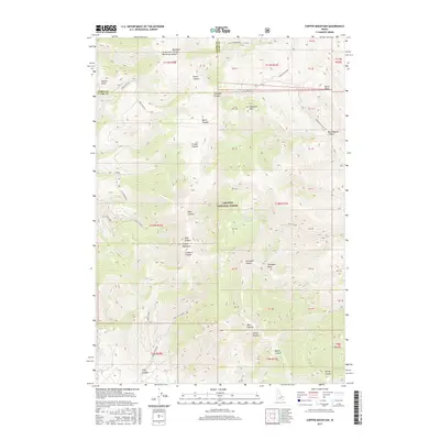
2017 Map of Copper Mountain
USGS Topo · Published 2017About this map
Targhee National Forest dominates this high-elevation landscape along the boundary of Lemhi and Clark Counties. The terrain is defined by a dense network of drainages and peaks, with Copper Mountain and Gallagher Peak serving as prominent landmarks. A deep history of resource extraction is suggested by the presence of the Skull Mine, located near the mouth of Skull Canyon. This industrial footprint is integrated into a complex system of canyons, including Pierce Canyon, Bear Wallow Canyon, and Goddard Canyon.
Find a feature on this map
53 named features on this map. Tap any name to fly to it.
Don’t see what you’re looking for? This feature index may not catch every label — zoom into the map to look around manually.
Map Details
Editions of this 2017 Copper Mountain Map
This is the sole edition of this map. No revisions or reprints were ever made.
Other maps of this area

1955 · Dubois
USGS Topo · 1:250,000

1957 · Scott Peak
USGS Topo · 1:62,500

1957 · Edie Ranch
USGS Topo · 1:62,500

1958 · Dubois
USGS Topo · 1:250,000

1969 · Shamrock Gulch
USGS Topo · 1:24,000

1969 · Eightmile Canyon
USGS Topo · 1:24,000

1969 · Copper Mtn
USGS Topo · 1:24,000
1969 · Blue Dome
USGS Topo · 1:24,000
1969 · Scott Butte
USGS Topo · 1:24,000
1969 · Snaky Canyon
USGS Topo · 1:24,000