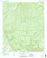
1964 Map of Copper Mtn
USGS Topo · Published 1970About this map
Sierra Ancha dominates this mid-1960s landscape, where high peaks and deep canyons define the cattle-and-wilderness character of the Tonto National Forest. Settlement is sparse, represented by working operations like the T Slash X Ranch and J-R Ranch, which are connected to the wider world by a remote landing strip and a network of jeep and pack trails. The landscape is dotted with water improvements essential for ranching in this arid environment, including Indian Camp Reservoir, Headquarters Pasture Tank, and Elephant Corral Spring. Land use at this time was a mix of grazing and exploration, evidenced by a prospect near Copper Mountain and the Dupont Cabin tucked into the headwaters of Dupont Canyon. The topography ranges from the high flats of Buckaroo Flats to the dramatic descent into Hells Hole along Workman Creek.
Find a feature on this map
59 named features on this map. Tap any name to fly to it.
Don’t see what you’re looking for? This feature index may not catch every label — zoom into the map to look around manually.
Map Details
Editions of this 1964 Copper Mtn Map
3 editions found
Other maps of this area

1886 · Holbrook
USGS Topo · 1:250,000

1887 · Verde
USGS Topo · 1:250,000

1892 · Verde
USGS Topo · 1:250,000

1893 · Holbrook
USGS Topo · 1:250,000

1907 · Roosevelt
USGS Topo · 1:125,000

1909 · Four Peaks
USGS Topo · 1:125,000

1912 · Roosevelt
USGS Topo · 1:125,000

1922 · Chrysotile
USGS Topo · 1:125,000

1937 · Diamond Butte
USGS Topo · 1:48,000

1943 · Diamond Butte
USGS Topo · 1:62,500