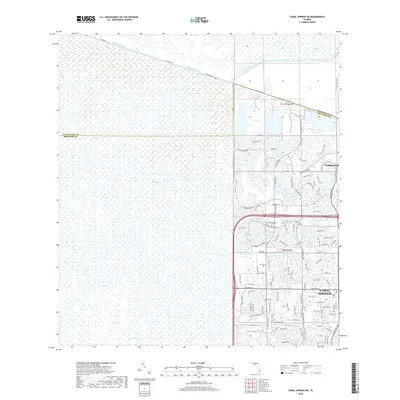
2018 Map of Coral Springs NE
USGS Topo · Published 2018About this map
The Everglades dominates the western half of this 2018 survey, illustrating the stark edge where Florida's natural wetlands meet the rapidly engineered urban expansion of Broward County. This sharp transition is defined by the Hillsboro Canal and L-40 Canal, which serve as both hydrological barriers and modern municipal boundaries. East of these waters, the suburban footprints of Parkland and Coral Springs are revealed in intricate detail, showcasing a dense network of residential developments and planned communities. Named routes like Loxahatchee Rd and Heron Bay Blvd weave through these neighborhoods, connecting numerous cul-de-sacs and local roads such as Osprey Trl and Nob Hill Rd. The map provides a precise look at the interface between conserved marshland and 21st-century residential planning, including the winding street patterns of the Parkland area.
Find a feature on this map
109 named features on this map. Tap any name to fly to it.
Don’t see what you’re looking for? This feature index may not catch every label — zoom into the map to look around manually.
Map Details
Editions of this 2018 Coral Springs NE Map
This is the sole edition of this map. No revisions or reprints were ever made.
Other maps of this area

1945 · Fort Lauderdale North
USGS Topo · 1:24,000

1946 · West Dixie Bend
USGS Topo · 1:24,000

1947 · Delmar Farms
USGS Topo · 1:24,000

1949 · Fort Lauderdale North
USGS Topo · 1:24,000

1949 · West Dixie Bend
USGS Topo · 1:24,000

1949 · Delmar Farms
USGS Topo · 1:24,000

1956 · West Palm Beach
USGS Topo · 1:250,000

1957 · West Palm Beach
USGS Topo · 1:250,000

1958 · West Palm Beach
USGS Topo · 1:250,000
1962 · Fort Lauderdale North
USGS Topo · 1:24,000