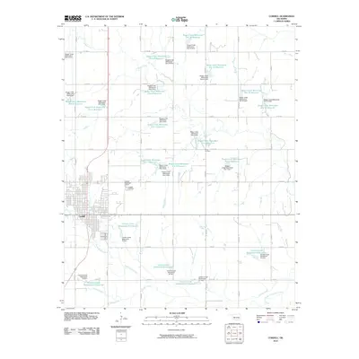
2010 Map of Cordell
USGS Topo · Published 2010About this map
Cordell serves as the focal point of this 2010 landscape, situated at the intersection of local routes that traverse the heart of Washita County. The town's layout is clearly defined alongside the Cordell Municipal Airport and the Cordell Cemetery, while the surrounding terrain is dominated by an extensive network of water management projects. This system is comprised of numerous reservoirs and dams along Boggy Creek and Cavalry Creek, including Cavalry Creek Watershed 25 Reservoir and Boggy Creek Watershed Site 1 Reservoir. This intricate engineering reflects a modern era of soil conservation and flood control in Oklahoma's agricultural plains. Rural landmarks such as the Sichar Cemetery to the northeast provide points of interest for genealogists, while the braided paths of North Cavalry Creek and South Fork Cavalry Creek illustrate the natural drainage patterns of the region.
Find a feature on this map
54 named features on this map. Tap any name to fly to it.
Don’t see what you’re looking for? This feature index may not catch every label — zoom into the map to look around manually.
Map Details
Editions of this 2010 Cordell Map
This is the sole edition of this map. No revisions or reprints were ever made.
Other maps of this area

1955 · Clinton
USGS Topo · 1:250,000

1956 · Cordell
USGS Topo · 1:62,500

1957 · Clinton
USGS Topo · 1:250,000

1957 · Dill City
USGS Topo · 1:62,500

1961 · Gotebo
USGS Topo · 1:62,500

1961 · Hobart
USGS Topo · 1:62,500

1976 · Dill City SE
USGS Topo · 1:24,000
1983 · Bessie
USGS Topo · 1:24,000
1983 · Corn
USGS Topo · 1:24,000
1983 · Dill City SE
USGS Topo · 1:24,000