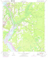
1948 Map of Cordesville
USGS Topo · Published 1979About this map
Francis Marion National Forest dominates the eastern landscape of this Berkeley County survey, where the heavy wetlands of Wadboo Swamp and Biggin Swamp meet the managed waterways of the Cooper River. The infrastructure of the late 1940s is evident at the edge of Lake Moultrie, showing the Pinopolis Dam and its associated powerplant. Human settlement is centered around Cordesville and the nearby Old Cordesville, with numerous rural institutions such as St Lukes Ch and Cordesville Sch serving the local community. The map also records the path of the Santee Canal (Abandoned) and the Tailrace Canal, tracing the evolution of regional water management. Further west, the growth of Moncks Corner is marked by the Berkeley Training Sch and the Seaboard Coast Line railroad, reflecting the town's role as a transportation and education hub.
Find a feature on this map
51 named features on this map. Tap any name to fly to it.
Don’t see what you’re looking for? This feature index may not catch every label — zoom into the map to look around manually.
Map Details
Editions of this 1948 Cordesville Map
2 editions found
Other maps of this area

1919 · Summerville
USGS Topo · 1:48,000

1919 · Cordesville
USGS Topo · 1:48,000

1920 · Chicora
USGS Topo · 1:48,000

1920 · Summerville
USGS Topo · 1:62,500

1921 · Chicora
USGS Topo · 1:62,500

1943 · Chicora
USGS Topo · 1:62,500

1943 · Bonneau
USGS Topo · 1:62,500

1944 · Summerville
USGS Topo · 1:62,500

1948 · Cordesville
USGS Topo · 1:24,000

1948 · Bethera
USGS Topo · 1:24,000