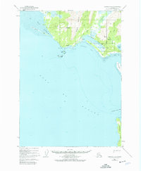
1950 Map of Cordova A-2
USGS Topo · Published 1974About this map
Katalla and its surrounding coastal industrial landscape appear here in a state of transition during the mid-20th century. This area of the Chugach National Forest was the site of Alaska's first oil production, and the map captures the remnants of that era, including the Katalla Oil Field and a nearby Oil Refinery. An Old Railroad Grade winds along the coast and through the foothills of Ragged Mountain, providing a trace of the transportation network once used to move resources toward Katalla Bay.
Find a feature on this map
37 named features on this map. Tap any name to fly to it.
Don’t see what you’re looking for? This feature index may not catch every label — zoom into the map to look around manually.
Map Details
Editions of this 1950 Cordova A-2 Map
4 editions found
Other maps of this area

1948 · Cordova
USGS Topo · 1:250,000

1948 · Middleton Island
USGS Topo · 1:250,000

1950 · Middleton Island
USGS Topo · 1:250,000

1950 · Cordova B-2
USGS Topo · 1:63,360

1950 · Cordova A-1
USGS Topo · 1:63,360

1950 · Cordova A-2
USGS Topo · 1:63,360

1951 · Cordova
USGS Topo · 1:250,000

1951 · Cordova B-1
USGS Topo · 1:63,360

1952 · Cordova B-3
USGS Topo · 1:63,360

1953 · Cordova A-2
USGS Topo · 1:63,360