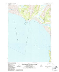
1950 Map of Cordova A-2
USGS Topo · Published 1988About this map
Katalla sits at the edge of the Gulf of Alaska on this 1950s-era topography, representing a landscape defined by early industrial exploration and the coastal wilderness. The map documents the specific infrastructure of the Katalla Oil Field, including a Drill Hole and an Old Railroad Grade that speaks to the area's history as the site of Alaska's first oil discovery. These remnants of human activity are set against the shifting geography of the Copper River Delta and the high peaks of Ragged Mountain. From the marshes of Katalla Slough to the offshore reaches of Kanak Island and Wingham Island, the survey provides an intricate view of the shoreline as it existed before later seismic shifts and environmental changes. The presence of a Landing Strip and scattered Cabins near Mirror Slough indicates the remote but active nature of this coastal enclave.
Find a feature on this map
36 named features on this map. Tap any name to fly to it.
Don’t see what you’re looking for? This feature index may not catch every label — zoom into the map to look around manually.
Map Details
Editions of this 1950 Cordova A-2 Map
4 editions found
Other maps of this area

1948 · Cordova
USGS Topo · 1:250,000

1948 · Middleton Island
USGS Topo · 1:250,000

1950 · Middleton Island
USGS Topo · 1:250,000

1950 · Cordova B-2
USGS Topo · 1:63,360

1950 · Cordova A-1
USGS Topo · 1:63,360

1950 · Cordova A-2
USGS Topo · 1:63,360

1951 · Cordova
USGS Topo · 1:250,000

1951 · Cordova B-1
USGS Topo · 1:63,360

1952 · Cordova B-3
USGS Topo · 1:63,360

1953 · Cordova A-2
USGS Topo · 1:63,360